AI SPACE HERITAGE


Redifining Archaeological Reseach
Harnessing AI for Cultural Preservation
Advancing Artificial Intelligence and 5 Dimensional Space Based Methodologies for Monitoring Cultural Heritage
AI-SPACE HERITAGE is redefining archaeological research. Although remote sensing is a well-known non-invasive method in recognition of archaeological features, with AI intergration, the accuracy of detecting sites of interest increases in high percentage.
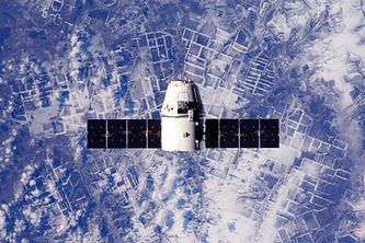
5D approach techniques, combine Earth Observation Data (Satellite Images, UAV photos, Lidar data, Digital Elevation Models ) with AI algorithms (Deep learning, Machine Learning, Neural Networks) in a meaning of 3D spatial dimensions + time + scale.
All these technological innovations, give time-consuming guide for archaeological research, monitoring even overlooked areas in a new perspective.
Overall, the project aims to identify hidden treasures remotely, protecting cultural heritage from threats like population growth, urban expansion, looting and severe natural hazards.
2025-2027
FORTH-SYNERGY
Institute for Mediterranean Studies (IMS)
Laboratory of Geophysical - Satellite Remote Sensing and Archaeo-environment
Institute of Computer Science (ICS)


Cutting-Edge Research
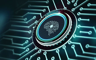
Artificial Intelligence
Innovative Approaches
By leveraging the capabilities of AI, remote sensing archaeology can become more efficient and accurate, enabling archaeologists to focus on interpretation and analysis rather than spending extensive time on data processing and initial assessments.
Artificial Intelligence (AI) algorithms (Neural Networks, Machine learning, Deep learning, etc.) are monitoring and detecting archaeological and cultural heritage remains in different spatial (local and regional) and time scales under different soil and geomorphological circumstances. The project aims to develop an advanced 5D Multi-purpose system for integrating and managing various types of information concerning remote sensing archaeology at 3D spatial dimensions (x,y, z) + time + scale.
Archaeology from Space
Ground-Breaking Techniques
The AI-SPΑCE HERITAGE research is based on three main original pillars: (1) Monitoring archaeological and cultural heritage sites such as crop marks, tombs and mounds with means of Earth Observation in 5D, (2) Incorporating Copernicus (Sentinel 1 and Sentinel 2) and Contributing missions data in Remote Sensing archaeology, and (3) Filling the gap between the actual process we are trying to automate with an AI-based system in remote sensing archaeology. The method aims to support archaeologists in their fieldwork, automating labor-intensive and time-consuming procedures.

Forth-Synergy
The Institute for Mediterranean Studies (IMS) and the Institute of Computer Science (ICS) of FORTH join their complementary expertise to advance AI-driven archaeological remote sensing within the AI-SPACE HERITAGE project.
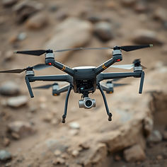
Dr. Dimitrios D. Alexakis (PI) and his team at IMS/FORTH are responsible for: a) the acquisition, curation, and expert interpretation of multi-source Earth Observation datasets, including multispectral and hyperspectral satellite imagery, UAV/drone aerial photography, and LiDAR-derived Digital Elevation Models; b) the preprocessing, photogrammetric alignment, and enhancement of the collected imagery; c) the expert annotation and validation of archaeological and geomorphological patterns and d) the development of site-specific geospatial layers and spatial indicators supporting the AI training process.
Dr. Anastasios Roussos (co-PI) and the rest of the (ICS) lab are pioneers in employing geometric, model-based, and Deep Learning frameworks for image understanding and 3D Computer Vision under challenging real-world conditions and using minimal image acquisition requirements. The integrated and innovative approach of AI-SPACE HERITAGE is based on a holistic and multi-disciplinary concept that stresses the complementarity of two different approaches (Geoinformatics, Deep Learning).
Equipment
Cutting-edge Research
With a UAV and multispectral sensor, we are focusing on a finer scale (local) and build models to detect objects of archaeological interest (pottery fragments, flint tools, etc) from high-resolution UAV imagery. We first perform field studies and standard photogrammetry to align, stitch, and orthorectify the acquired UAV images, producing a seamless, georeferenced orthomosaic.
Contact us
Address
Institute for Mediterranean Studies (IMS)
Laboratory of Geophysical - Satellite Remote Sensing and Archaeo-environment
Nikiforou Foka 130, 74 100 Rethymno, PO BOX 119
Institute of Computer Science (ICS),
Foundation for Research and Technology - Hellas (FORTH),
N. Plastira 100, Vassilika Vouton,
GR70013 Heraklion, Crete, Greece
Phone
Dr. Dimitrios Alexakis
(+30) 283110 6023
Dr. Anastasios Roussos
Dr. Dimitrios Alexakis
Dr. Anastasios Roussos